Sinkhole inspections in PA and NJ serve as a critical diagnostic tool for property owners concerned about shifting ground or structural instability. These investigations determine if the soil beneath a building is collapsing or if a void is forming. A professional inspection relies on a combination of visual observations, advanced technology, and physical testing.
When owners notice suspicious cracks or depressions, they often turn to experts like Earth Engineering Inc. (EEI) to provide a definitive answer. For decades, Earth Engineering Inc. has specialized in geotechnical investigations, helping clients navigate the complexities of subsurface hazards. A professional inspection by a firm like EEI relies on a combination of visual observations, advanced technology, and physical testing to deliver the safety of a structure.
Engineers and geologists follow protocol to identify subsurface anomalies that are invisible to the naked eye. They collect data to create a clear picture of the geological conditions affecting the property. This process further evaluates whether a potential sinkhole exists and helps define the necessary repair strategy. The procedure typically moves from non-invasive surface scans to invasive drilling and soil sampling. Each step provides a different layer of information regarding the stability of the earth below.
How to Conduct a Preliminary Property Check
Before hiring a professional engineering firm, homeowners can perform a basic check to see if an inspection is warranted. This routine helps identify changes in the property condition over time.
How to Monitor Your Home for Sinkhole Activity:
- Inspect the Exterior Foundation: Walk the perimeter and look at the exposed concrete. Check for hairline cracks that run vertically or diagonally. Tip: If a nickel fits in the crack, it requires professional attention.
- Check Interior Door Alignment: Open and close every door. Look at the gap between the door and the frame. If a door latches perfectly one month and sticks the next, this suggests active movement.
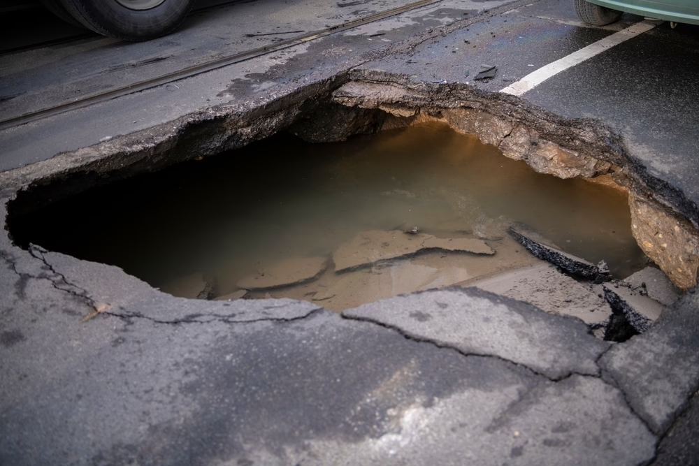
- Survey the Yard for Depressions: Look for circular patches of dead grass or areas where the ground slopes inward. Watch for fence posts that have started to lean or “drunken” trees that look tilted.
Visual Site Assessment and Property Survey
The first phase of any investigation involves a thorough visual examination. At Earth Engineering Inc., qualified engineers or geologists walk the property to document distress signs that correlate with ground movement. They look for specific patterns of damage that indicate the foundation is settling unevenly.
Inspectors examine the exterior of the building for stair-step cracks in stucco, brick, or block walls. They also check the foundation for separation from the soil or visible fractures in the concrete slab. These physical symptoms often point to where the subsurface activity is most intense. Visual inspections are also conducted around the building to evaluate subsurface depressions or open sinkholes.
The interior inspection focuses on functional issues caused by a shifting frame, such as doors and windows that no longer close properly. Inspectors also look for:
- Cracks in drywall or plaster.
- Sloping floors.
- Separation between walls and ceilings.
- New gaps in baseboards or crown molding.
Geophysical Testing Methods
After the visual survey, the investigation geophysical testing may be warranted to see what is happening underground without excavating. This stage uses specialized equipment to detect variations in soil density and identify potential voids. These methods allow for scanning large areas of the property relatively quickly and efficiently.
Ground Penetrating Radar (GPR)
Ground Penetrating Radar functions like an X-ray for the earth and is effective for shallow investigations. A technician moves a cart-mounted GPR unit across the property in a grid pattern to collect data. The device transmits high-frequency radio waves into the ground and records the signals that bounce back.
When the radio waves hit a buried object, a pipe, or a change in soil layers, the reflection pattern changes. If the waves encounter a void or air pocket, the signal reflects differently than it does through typical subsurface conditions. GPR is excellent for identifying anomalies within the first 10 to 20 feet of the surface. However, its effectiveness decreases in soils with high clay content. This is why Earth Engineering Inc. often recommends pairing GPR with other methods to deliver a great view.
Electrical Resistivity Imaging (ERI)
Electrical Resistivity Imaging allows engineers to see deeper into the ground than radar typically permits. This method involves placing a line of electrodes into the ground connected by a cable. The system sends an electrical current through the stakes and measures how much resistance the soil offers.
Different materials conduct electricity differently:
- Clay: Highly conductive (low resistance).
- Air-filled voids/Dry sand: Highly resistive (high resistance).
- Water-saturated zones: Variable, but distinct from solid rock.
By measuring these differences, the software builds a color-coded 2D profile of the subsurface geology. This image highlights areas of loose soil or voided spaces that might indicate sinkhole activity. ERI is particularly useful for mapping the limestone bedrock profile and identifying deep “throat” features of a sinkhole.
Microgravity Surveys
Microgravity is a geophysical method used to detect subtle variations in the Earth’s gravitational field caused by differences in subsurface density. For engineers, microgravity surveys are a valuable non-invasive tool for identifying voids, sinkholes, buried utilities, abandoned mine workings, and other geotechnical hazards that can compromise construction safety and infrastructure performance.
Microgravity testing involves highly sensitive gravimeters that measure minute changes in gravitational acceleration (typically in microgals). These changes reflect variations in subsurface mass distribution; less dense zones (e.g., cavities or voids) result in lower gravity readings, while denser materials (e.g., boulders or backfilled trenches) produce higher readings.
The data is corrected for factors such as elevation, terrain, and drift, and then processed to generate a gravity anomaly map, which highlights areas of potential concern.
Multichannel Analysis of Surface Waves (MASW)
In karst regions where sinkholes and subsurface voids pose significant geotechnical challenges, Multichannel Analysis of Surface Waves (MASW) provides a valuable non-invasive tool for identifying zones of low subsurface stiffness that may indicate the presence of solution features or incipient collapse.
MASW is a surface-based seismic method that uses Rayleigh wave dispersion to generate shear wave velocity (Vs) profiles of the subsurface. Changes in Vs can indicate variations in material stiffness and density; key indicators when evaluating the potential for subsurface voids, loose soils, or collapse-prone zones common in karst environments.
Standard Penetration Testing (SPT)
Physical verification through drilling is a definitive way to confirm a sinkhole. Earth Engineering Inc. utilizes Standard Penetration Testing (SPT) to collect soil samples and measure resistance directly. A large drilling rig, often mounted on a truck or track vehicle, performs this heavy-duty work.
The process works by dropping a 140-pound hammer from a height of 30 inches onto the drill rod. The geologist/engineer counts how many blows it takes to drive the sampler one foot into the ground. This “blow count” (N-value) directly correlates to the relative density/consistency of the soil.
| Soil Condition | Observation | Interpretation |
| Suitable Sunsurface Condition | Blow counts increase with depth | Stable material |
| Loose/Raveled Soil | Very low blow counts | Potential sinkhole activity |
| Void/Cavity | “Weight of Rod” (rod sinks without hammer) | Confirmed subsurface opening |
Laboratory Analysis and Soil Classification
After the field team from Earth Engineering Inc. collects the soil samples, they transport them to a laboratory for detailed analysis. Tests are run in the laboratory to determine the moisture content, plasticity, and soil type.
This data helps engineers distinguish between different types of ground movement. For example, high-plasticity clay can shrink and swell with seasonal moisture changes, causing cracks that mimic sinkhole damage. Differentiating between clay shrinkage and true sinkhole activity is vital for the final diagnosis.
Final Engineering Report and Recommendations
The culmination of the inspection is the comprehensive engineering report. This document synthesizes the visual survey, geophysical data (GPR/ERI/MASW/MicroGravity), drilling logs, and lab results into a final conclusion. The engineers at Earth Engineering Inc. certify whether the data meets the criteria for sinkhole activity as defined by local statutes and geological standards.
If a sinkhole is confirmed, the report outlines a remediation plan to stabilize the property. This typically involves:
- Compaction/Pressure Grouting: Injecting a mortar-like grout into the ground to fill voids and densify the soil.
- Underpinning: Installing steel piers (pins) to transfer the weight of the house to stable bedrock.
- Chemical Grouting: Using polyurethane foam to stabilize shallow soil layers.
- Excavation and replacement technique using the inverted filter method.
Insurance companies and contractors rely heavily on the Earth Engineering Inc. report to authorize claims and execute repairs. The document serves as the official record of the property’s geological condition and dictates the scope of work required to make the building safe again.
Conclusion
A sinkhole inspection is a systematic process designed to uncover what is happening beneath the surface of a property. It moves logically from visual observations to high-tech scanning and finally to physical drilling. Each method adds a piece to the puzzle, allowing experts like those at Earth Engineering Inc. to diagnose the issue accurately.
Property owners dealing with potential foundation issues should rely on these professional assessments rather than guessing. Identifying the problem early often leads to more manageable and less expensive repairs. This approach provides the certainty needed to protect your investment and your home.
Whether it be for sinkhole inspections in NJ, geotechnical investigations in the region or environmental testing in NJ or PA, Earth Engineering Inc. is here to help you with your project.