
Before you know it, it’s far too late. It’s no secret that sinkholes are a silent threat, often forming with little warning and causing significant damage to homes, infrastructure, and the environment. In regions with karst geology where soluble rocks like limestone and dolomite are common, the risk is especially high. Detecting these hidden voids before they become hazards is not just a matter of safety; it is very useful for responsible property development and infrastructure management.
Why Geophysical Technology Matters for Sinkhole Detection
Traditional geotechnical methods, such as the utilization of test borings, only provide information at specific points. This approach can miss critical voids or cavities between test locations, especially in highly variable karst terrain.
In contrast, geophysical methods offer continuous mapping of the subsurface, giving a more complete picture of what lies beneath the ground. This not only improves the accuracy of sinkhole detection but also helps in deciding if and where to conduct remedial measures to reduce the risk of unexpected collapses and costly repairs.
Understanding the Science: How Geophysical Tools Work
Geophysical technology uses non-invasive techniques to measure variations in the physical properties of the earth. By analyzing how electrical currents, electromagnetic waves, seismic vibrations, or gravimetric forces move through the ground, experts can identify changes in soil, rock, moisture, and the presence of voids or fractures. These differences are often the telltale signs of developing sinkholes.
Key Geophysical Methods in the Detection of Sinkholes
Several state-of-the-art geophysical tools, each chosen for its strengths in detecting and mapping subsurface anomalies associated with sinkholes can be employed. The most effective and widely used methods are:
1. Ground-Penetrating Radar (GPR)
Ground-penetrating radar is a powerful tool for detecting shallow subsurface anomalies. GPR works by emitting high-frequency electromagnetic pulses into the ground and measuring the reflected signals. When these pulses encounter a change in the subsurface, such as an air-filled cavity or a change in soil composition, the signal is reflected back, creating a detailed image of the subsurface layers.
Advantages of GPR:
- Provides high-resolution images of shallow features
- Sensitive to changes in material, moisture, and voids
- Allows for quick data collection and real-time results
Limitations:
- Effectiveness decreases in clay-rich or highly conductive soils
- Best suited for mapping shallow sinkholes or voids
GPR is used to scan areas where surface depressions, cracks, or other warning signs suggest possible sinkhole activity. By interpreting the radar profiles, the location and size of potential hazards before they become visible at the surface can be pinpointed.
2. Electrical Resistivity Tomography (ERT)
Electrical Resistivity Tomography is another essential method for sinkhole detection, especially in karst environments. ERT involves placing a series of electrodes in the ground and passing a controlled electrical current between them. The resistance encountered by the current varies depending on the subsurface materials. Solid rock, saturated soil, or air-filled cavities all have distinct resistivity signatures.
Advantages of ERT:
- Capable of imaging deeper features
- Effective in a variety of soil and rock types
- Can delineate the shape, size, and depth of subsurface voids and fractures
ERT is particularly effective for mapping the extent of buried sinkholes and associated cavities. By using different electrode spacings and configurations, two-dimensional and even three-dimensional images of the subsurface can be created, helping clients understand the full scope of potential hazards.
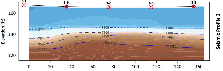
3. Seismic Multichannel Analysis of Surface Waves (MASW)
Seismic geophysical techniques use the propagation of sound waves through the ground to detect changes in subsurface density and structure. When a seismic wave encounters a void or a change in material, its speed and direction are altered. By analyzing these changes, EEI can identify the presence of sinkholes, fractures, and other anomalies.
In karst regions where sinkholes and subsurface voids pose significant geotechnical challenges, Multichannel Analysis of Surface Waves (MASW) provides a valuable non-invasive tool for identifying zones of low subsurface stiffness that may indicate the presence of solution features or incipient collapse.
What is MASW?
MASW is a surface-based seismic method that uses Rayleigh wave dispersion to generate shear wave velocity (Vs) profiles of the subsurface. Changes in Vs can indicate variations in material stiffness and density—key indicators when evaluating the potential for subsurface voids, loose soils, or collapse-prone zones common in karst environments.
Why Use MASW for Karst Investigations?
- Non-invasive: Requires no drilling or trenching—ideal for initial screening in environmentally or logistically sensitive areas
- Detects low-stiffness zones: Shear wave velocity anomalies can suggest fractured rock, loose overburden, or void migration paths
- 2D profiling: MASW can generate continuous cross-sectional views of the subsurface, helping visualize subsurface structure and layering changes over distance
- Supports risk mitigation: MASW helps focus intrusive testing or further geophysics in suspected high-risk areas
Engineering Applications in Karst
- Mapping weathered bedrock or solution-widened fractures
- Detecting soft zones above voids or collapses
- Screening sites for differential stiffness indicative of sinkhole activity
- Supporting foundation design by identifying variable subsurface conditions
What You Can Expect from a MASW Survey
- Surface wave testing using a seismic source and geophone array
- Inversion of dispersion data to generate 1D or 2D shear wave velocity profiles
- Identification of anomalously low-Vs zones that may correlate with subsurface voids or weak fill material
- Integration with geological mapping, borehole logs, or other geophysical data for more robust interpretation
Limitations
- MASW does not directly image voids but highlights stiffness contrasts that may suggest them
- Interpretation depends on site-specific geology and should be supported by ground truthing when possible
- Maximum depth is typically limited to ~30–100 feet depending on array length and source energy
When investigating sites in karst terrain, MASW offers engineers a practical and efficient method to detect subsurface anomalies that may be indicative of sinkhole activity. By mapping shear wave velocity variations, MASW supports early risk identification, improves the focus of follow-up testing, and helps design teams plan safer, more resilient foundations.
Seismic methods are especially valuable when used in combination with ERT and GPR, providing a comprehensive understanding of the subsurface.
4. Microgravity
In regions underlain by limestone or dolomite, undetected subsurface voids can pose serious risks to construction and infrastructure. Microgravity geophysical testing is a highly sensitive, non-invasive method used by engineers to identify these hidden hazards—particularly sinkholes and solution cavities common in karst environments.
How Microgravity Works
Microgravity surveys detect subtle variations in the Earth’s gravitational field that result from differences in subsurface density. A low-density anomaly, such as an air- or water-filled void, will produce a small but measurable decrease in gravitational acceleration.
Field crews collect gravity readings at a grid of points using a high-precision gravimeter, while also recording accurate elevation data. After correcting for elevation, instrument drift, and terrain effects, the result is a gravity anomaly map that highlights areas where potential sinkholes or voids may exist.
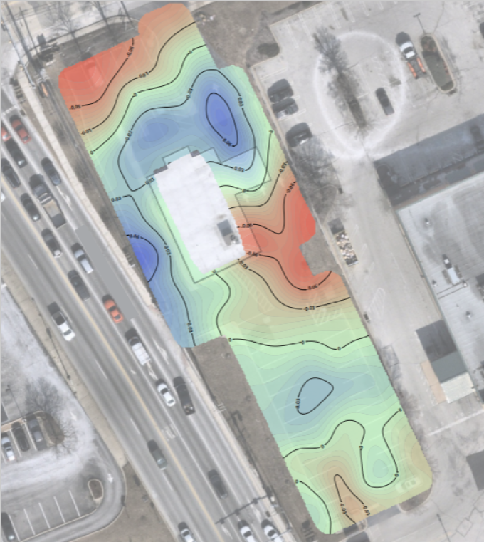
Why Engineers Use Microgravity in Karst Areas
- Early risk identification: Detects sinkholes, voids, or collapse-prone zones before construction begins
- Non-destructive: No drilling, vibration, or ground disturbance required
- High sensitivity: Capable of detecting small or partially collapsed features at shallow depths
- Cost-effective targeting: Helps focus follow-up borings or trenching where they’re needed most
Typical Applications
- Site characterization for buildings, roadways, or utilities in karst regions
- Pre-construction due diligence on undeveloped land
- Risk assessment following surface subsidence or nearby sinkhole activity
- Supporting DOT or municipal projects where public safety is a concern
Deliverables Include:
- Corrected gravity anomaly maps
- Interpreted low-density targets
- Void location estimates and depth ranges
- Recommendations for geotechnical follow-up (borings, geoprobes, etc.)
Limitations
- Best suited to relatively flat terrain
- Requires accurate elevation control (e.g., differential GPS or total station)
- Interpretation should be supported by local geology and borehole data
In karst terrain, early detection of subsurface voids is critical to avoid foundation failure, infrastructure damage, or construction delays. Microgravity offers engineers a reliable, non-invasive tool to assess sinkhole risk and build a safer, more informed site investigation program.
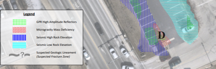
The Power of a Multi-Geophysical Approach
No single geophysical method is perfect for every site or scenario. That is why EEI often employs a multi-geophysical approach, combining GPR, ERT, and seismic methods to cross-validate findings and improve accuracy. This integrated strategy allows for:
- Detection of both shallow and deep voids
- Confirmation of anomalies identified by one method with another
- More reliable mapping of complex karst features
By layering data from multiple sources, EEI provides clients with a clear, actionable understanding of subsurface risks and can create a plan of action for sinkhole repair in PA and beyond.
Advantages for Property Owners, Developers, and Municipalities
For property owners, developers, and municipalities, the benefits of geophysical sinkhole detection are clear:
- Detect voids and fractures before they cause surface collapse
- Target remediation efforts, reducing unnecessary excavation or repairs
- Meet safety and environmental standards for new construction and redevelopment
- Make informed decisions about property use and investment
Geophysical expertise ensures that clients receive not just data, but clear recommendations and practical solutions.
Limitations and Considerations
While geophysical methods are powerful, they do have limitations. Factors such as soil type, moisture content, and the presence of utilities can affect data quality. For example, GPR is less effective in clay-rich soils, while ERT requires careful electrode placement and interpretation. EEI’s experienced geophysicists account for these variables, selecting the best combination of methods and tailoring each investigation to the unique conditions of the site.
The Future of Sinkhole Detection
As technology continues to advance, geophysical methods are becoming more accurate, efficient, and accessible. Innovations such as computer-controlled multi-electrode resistivity surveys and advanced seismic data processing are making it possible to collect and interpret data faster and with greater detail than ever before.
The importance of these advancements, as well as construction site inspection in Philadelphia and the surrounding areas has never been more relevant. EEI remains committed to staying at the cutting edge of these developments, ensuring clients benefit from the latest tools and techniques.
Why You Can Trust EEI for Reliable Sinkhole Detection
Sinkholes may be hidden, but with the right technology and expertise, they do not have to be a surprise. Earth Engineering Incorporated combines advanced geophysical methods, ground-penetrating radar, electrical resistivity tomography, and seismic surveys to provide comprehensive, non-invasive sinkhole detection and mapping. This proactive approach helps clients protect their investments, ensure safety, and plan for the future with confidence.
If you find yourself concerned about sinkhole risks on your property or project site, reach out to EEI. Their team of experts will design a tailored investigation using the most effective geophysical tools available, giving you the knowledge you need to act before a problem arises. With EEI, you can trust that what lies beneath will not catch you off guard.